


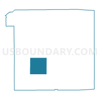
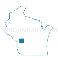
WELLS - T 1 Voting District, Monroe County, Wisconsin
About
Outline

Summary
| Unique Area Identifier | 695613 |
| Name | WELLS - T 1 Voting District |
| County | Monroe County |
| State | Wisconsin |
| Area (square miles) | 35.68 |
| Land Area (square miles) | 35.68 |
| Water Area (square miles) | 0.00 |
| % of Land Area | 100.00 |
| % of Water Area | 0.00 |
| Latitude of the Internal Point | 43.85608410 |
| Longtitude of the Internal Point | -90.73077700 |
Maps

Graphs
Select a template below for downloading or customizing gragh for WELLS - T 1 Voting District, Monroe County, Wisconsin


Neighbors
Neighoring Voting District (by Name) Neighboring Voting District on the Map
- ADRIAN - T 1 Voting District, Monroe County, WI
- ANGELO - T 2 Voting District, Monroe County, WI
- ANGELO - T 3 Voting District, Monroe County, WI
- JEFFERSON - T 1 Voting District, Monroe County, WI
- LEON - T 1 Voting District, Monroe County, WI
- PORTLAND - T 1 Voting District, Monroe County, WI
- RIDGEVILLE - T 1 Voting District, Monroe County, WI
- SHELDON - T 1 Voting District, Monroe County, WI
- SPARTA - T 1 Voting District, Monroe County, WI
Top 10 Neighboring County Subdivision (by Population) Neighboring County Subdivision on the Map
- Sparta town, Monroe County, WI (3,128)
- Angelo town, Monroe County, WI (1,296)
- Leon town, Monroe County, WI (1,086)
- Jefferson town, Monroe County, WI (819)
- Portland town, Monroe County, WI (808)
- Adrian town, Monroe County, WI (762)
- Sheldon town, Monroe County, WI (727)
- Wells town, Monroe County, WI (519)
- Ridgeville town, Monroe County, WI (501)
Top 10 Neighboring Unified School District (by Population) Neighboring Unified School District on the Map
- Sparta Area School District, WI (17,279)
- Cashton School District, WI (4,063)
- Norwalk-Ontario-Wilton School District, WI (2,902)
Top 10 Neighboring State Legislative District Lower Chamber (by Population) Neighboring State Legislative District Lower Chamber on the Map
- Assembly District 94, WI (62,641)
- Assembly District 92, WI (58,894)
- Assembly District 96, WI (55,740)
Top 10 Neighboring State Legislative District Upper Chamber (by Population) Neighboring State Legislative District Upper Chamber on the Map
Top 10 Neighboring 111th Congressional District (by Population) Neighboring 111th Congressional District on the Map
Top 10 Neighboring Census Tract (by Population) Neighboring Census Tract on the Map
- Census Tract 9509, Monroe County, WI (5,469)
- Census Tract 9502, Monroe County, WI (4,892)
- Census Tract 9508, Monroe County, WI (4,421)